Porkies Shakedown Hike - 5 August to 11 August, 2023
Prologue:
I had originally hoped ( planned ) on hiking the sections of the Pacific Crest Trail that I missed last year, but life had other plans. When my boss told me I could take a week off in early August to go hiking, I jumped at the chance. I had wanted to hike the Pictured Rocks National Lakeshore, but I found the website ( www,recreation.gov ) too awkward and cumbersome to use. Instead, I decided to revisit The Porcupine Mountains Wilderness State Park.
The Porcupine Mountains Wilderness State Park ( aka " The Porkies " ) is located in the far northwestern corner of Michigan's Upper Peninsula. The Porkies has the distinction of having the largest stand of Uncut Maple / Hemlock forest between the Rocky Mountains and the Adirondack Mountains of New York state. The Ojibway people called these sharp, steep ridges "Crouched Porcupines". I will admit, compared to the Sierra Nevada mountains, the porkies barely qualify as foothills and the waterfalls are nowhere near as large or wonderful as the ones you see on the PCT, but The Porkies have two lakes that people will travel for miles to see. One of them is, ahem... Superior to any lake you will find on the PCT, and the other is the majestic "Lake of The Clouds". The area has some of the purest copper in the world, but it is so hard to extract from the rocks, that none of the 45 mines that were started in the area ever made any money. Near the town of Ontonagon, 10 miles east of the park, they found a pure "copper nugget" that weighs 3,708 pounds. It's at the Smithsonian.
In the 1930's The Porkies almost became a National Park, but the bill died in Congress. In 1945, concerned Michiganders (people who live in Michigan), persuaded the Governor to call a Special Season of the State Legislature to pass a law protecting the Porkies as a State Park. In 1946, the year the park first opened, it was visited by 70,000 people ! Keep in mind, this was 10 years before "Big Mac" (the Mackinaw Bridge linking the upper and lower peninsulas) was built, and years before most of the major highways were built. To this day, it is a very popular place to visit, with people coming from all over the country to see it.
My purpose was to test a few new items of backpacking equipment and to ( hopefully ) refresh my hiking skills in a wonderful but challenging place. The items I am testing are my new backpack, a hipsack that I picked up on my short sojourn on the Appalachian Trail in 2020, a battery for charging electronics on the trail, and a small light that also works as a pump to inflate my air mattress.
Due to the large numbers of people visiting the park, and to prevent excessive damage to wilderness, you are required to camp in designated campsites. You must reserve your campsites in advance on the Michigan DNR website. Up until 4 or 5 years ago, a Backcountry Camping Permit allowed you to camp anywhere. The problem is, to many people camping in too many places, damages to much park land.
 |
| My Route through the Porkies |
Saturday, August 5
I left home at about 11 AM and made it to the Straits of Mackinaw ( where the bridge is ) about 3PM. I spent the afternoon and evening examining Fort Michilmackinac. The fort was originally built by the French, not to control the straits ( the canons of the 1600's didn't have the range for that: Big Mac is 5 miles long ), but to control the fur trade. After the French and Indian War of 1763, it was taken over by the British. The British abandoned the fort during the American Revolution, moving their fort to Mackinaw Island, which allowed them greater control over ships going through the straits.
 |
| The Reconstructed Fort is built on the foundations of the Original Fort |
 |
| A replica of the canoes that the fur traders used. It could carry 10 men and cargo up to 4 tons. The reenactor is dressed as a 17th century french fur trader. Notice "Big Mac" in the background. |
 |
| Two reenactors sewing in the kitchen of the governors house |
 |
| The garden of the Governor's House. They planted in raised beds because of the sandy soil. |
 |
| The Doctor ISN'T in, but he left some medicine behind. |
 |
| An Anishnaabek ( Odawa and Ojibwa Nations) house. Notice that the roof is made of Cedar and Birch bark. |
 |
| A demonstration of Baggataway, which is the origin of Lacrosse |
 |
| You know the old saying "Beware of Greeks when they come bearing gifts" ? The British at Michilmackinac had their own version: " Beware of Anishnaabek when they start playing Baggataway." |
At sunset I toke some photos of the bridge before calling it a night. I stayed in Mackinaw City, south of the bridge.
 |
| The Mackinaw Bridge at last light |
Sunday, August 6 ( 4 Miles +/-)
I slept in and didn't get on the road until 8AM. I wasn't in a real hurry. It's a 5 hour drive from Big Mac to the Porkies, but the days hike was only about 4 miles, so it shouldn't take long. My first stop was the Temporary Visitor Center ( the permanent one is being renovated ) to check in and get my permit. After getting my permit, I wandered over to the gift shop, because I forgot to bring insect repellent. HOLY SMOKES !! $15 for a small can of bug spray ( that sells for $3 - 5 in Jackson ). ARE YOU KIDDING ME ! Sheesh ! I'll take my chances with the bugs.
My plan was to park at the Presque Isle unit on the west side of the park and hike in from there. After parking my vehicle , I put on my pack and started hiking. I realized immediately that I had already made some mistakes.
1.) I forgot to charge my GPS unit, so nobody could track my progress. More importantly, if I had needed to call for help, I wouldn't have been able to do so. OOPS !!
2.) I forgot to bring some water. Good thing I wasn't on the PCT, or I'd would've died of heat stroke. Fortunately, the Presque Isle river is only a mile away, so no real harm.
3.) I forgot to download maps for the park. Granted, I had a paper map and there are plenty of signs so I won't get lost. Still it would be nice to have some idea on the topography of the trail.
I started hiking about 5 PM and made it to the Presque Isle River fairly quickly. I filtered 2 Liters of water and spent some time photographing the "waterfalls" I grant you, compared to what you see on the PCT, these falls would barely qualify as "rapids" but they are still fun to photograph.


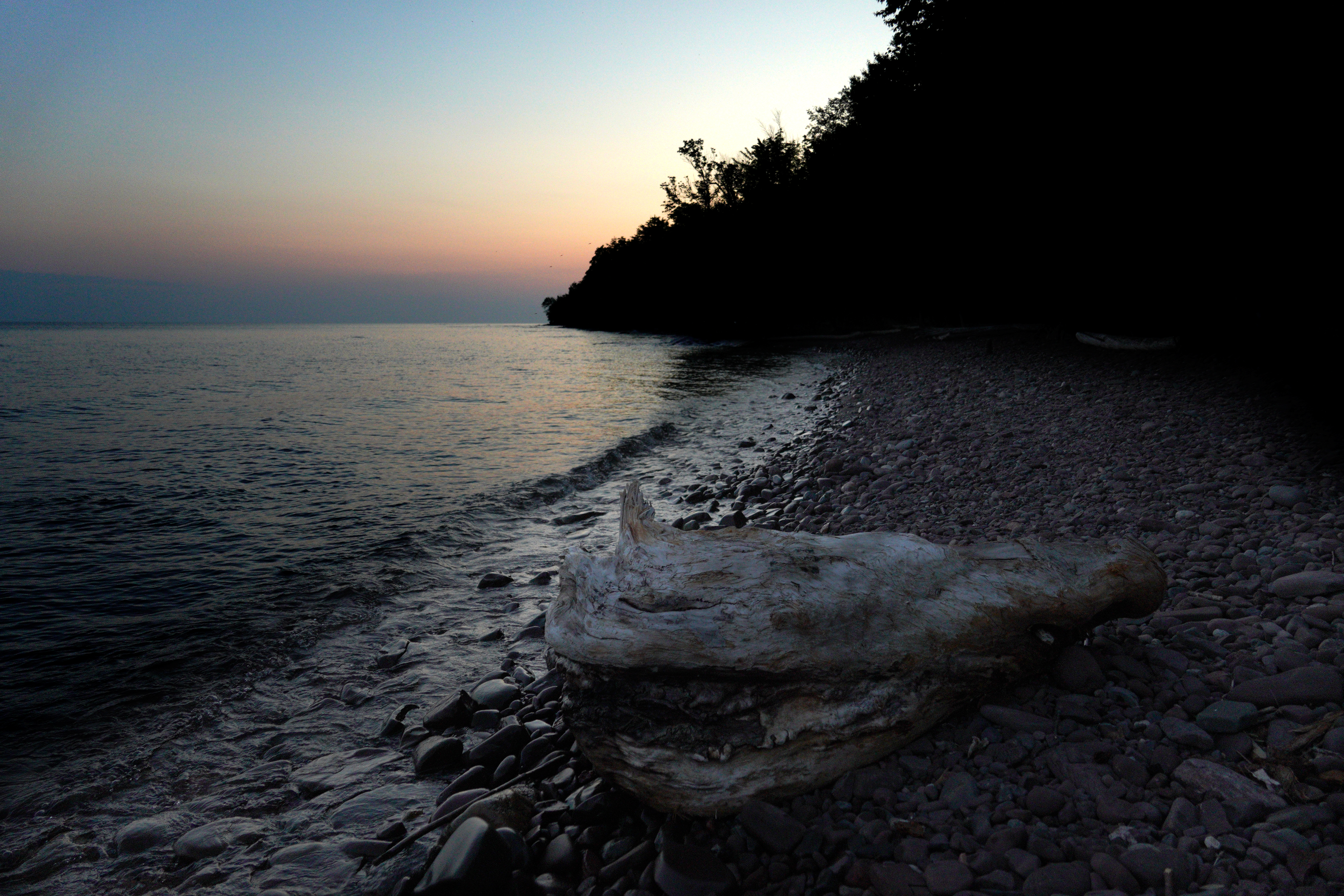
I made it to camp around 7 and quickly set up camp. My site had a decent view looking over Lake Superior, but the climb down to the lake was very steep, so I didn't bother.
 |
| A Superior Sunset |
Monday, August 7 ( 3 Miles )
Today was another short day. I got up at 6, took my time packing, left camp at 8 and still made it to my next campsite by 11.
 |
| A "Porkies Bear Hang" The best way in the world to hang your foodbag. |
 |
| Don't ask me what this is, because after 30 minutes of research, I don't know. |
I set up camp, washed my clothes in Lake Superior and took a bath in the Little Carp River. My back has been bothering me, so I will see if adjusting the pack will help.
 |
| Using the latest tech, a combination of Wind and Solar power, to dry my clothes. |
This site has much better access to the lake. During the afternoon, I watched 10 Common Mergansers swimming and diving for fish where the Little Carp River empties into Lake Superior.
 |
| 10 Common Mergansers resting on the riverbank. |


During the evening, there were a pair of Common Loons swimming just offshore in the Lake. I deliberately selected the sites I camped at last night and tonight, so I would have the opportunity to photograph a sunset over Lake Superior. I was also hoping to photograph the stars, but it was cloudy both nights.
 | |
| A "Superior", Superior Sunset |
Tuesday, August 8 ( 15 Miles +/- )
Today was a challenging day, whose challenges started last night. Last night, one of the zippers on my tent broke. Then I was awakened at 2 AM by a little boy in the next campsite screaming at the top of his lungs. He must have screamed for 10 to 15 minutes before his parents got him settled.
I woke up at 5:30 and did some birdwatching before departing at 6:45.
 | |
| Sunrise |

To cap it off, I saw a first year Bald Eagle near the mouth of the river.
 |
| The Lake Superior Trail lives up to it's name. I spent several hours hiking near the lakeshore. |
 |
| A plaque near the log "bridge". |
I reached the Big Carp River around 8 AM, and started having a slight panic attack when I saw the "bridge" over the river. It was a log, granted a big log, but still a log with a slant over a deep, fast flowing stretch of the Big Carp River.
 |
| The "bridge" is steeper than it looks and the water is 6' deep and flowing fast |
As I was pondering how to cross the river (as Sarah will tell you, I don't do very well on log bridges), Dan came out of the cabin on the other side. Of course, he had no problem waltzing over the bridge. Then he told me his kids had been running across it for a day or so. OK ! FINE !! It's a safe bridge ! But they weren't crossing it with a heavy pack ! Then he pointed out that the "Real" bridge was about 300 feet downstream. Whew !!
 |
| Hey Mister !! What's matter ?? Can't you read the sign ?? |
After crossing the "Real" bridge, I filled up my water supply,
because it was at least 10 miles to the next water source.
 |
| That's more like it !! |
Kind of hard to believe that you have to do a PCT Desert water carry in the middle of what is called the "Water Wonderland", but it's true. I reached Highway 117 around 2 PM.
I was really thirsty today, because by the time I reached the Highway, I was almost out of water. Lucky for me, a kind man gave me 2 Liters of Water. Thanks Tim !! I spent some time chatting with Bill, who mans the ticket booth near Lake of The Clouds. He said that he carries a Storm Whistle to scare the bears away. Supposedly, they are sensitive to shrill sounds, and the whistle scares them away. I haven't seen any reports that verify this, but it might be worth carrying. If nothing else, it would make a good emergency signal as it is much louder than a regular whistle.
I then hiked the half mile to the Lake of The Clouds parking lot, and started looking for my campsite.
 |
| A road walk in a wilderness ? Good thing it's only 0.5 miles. |
I picked today's campsite because it is really close to the Escarpment overlooking Lake of The Clouds. Unfortunately, I couldn't find it !!
 |
| Lake of the Clouds. With the right weather, you can get some awesome sunrises, sunsets and views of the Milky Way. Of course it rained on my parade... |
I spent the next 3 or 4 hours looking for it, but didn't see any sign making it's location. Remember what I said about camping in designated sites only ?? All ( well almost all ) of them are marked. In most cases, there will even be a sign on the trail to indicate which way to go, when you are a couple of miles away. Finally, around 6:30 PM, I decided I was going to camp near the parking lot. At least that way, I wouldn't be damaging any vegetation. I was joined by three fishermen who got lost and ran out of water, Thankfully for all of us, some kind folks gave us some water, and one of the fishermen got a ride to his vehicle. They are going to town in the morning to get water, because there is none up here. The nearest water is 5 miles away.
I got my tent set up just in time. I set up everything else and settled in. As soon as I got everything set up, it started to rain... HARD. I finally managed to download some maps for the area, but they don't show the individual campsites the way the Far Out Ap does. BUMMER ! Before you ask: No, Far Out does not have a map of the Porkies, and according to an email I received, they are not planning on making one. But at least, I now have a topographical map of the area. I also managed to bluetooth my phone to my GPS ( something I never managed on the PCT ), which makes it easier to send messages, at the expense of more rapid drain of the phone and GPS batteries. Speaking of batteries, I'm not sure the 36,000Mah battery is all that it claims to be. Charging my phone and my GPS, took it down to 50%.
It stopped raining for a bit around 8. Then a heavy thunderstorm rolled in around 9:30. When it stopped raining around 10, a Park Ranger told us we had to move. the fishermen piled into the vehicle and drove off. After I packed up, I explained to the Park Ranger that I couldn't find my spot, and he showed me where it was. I must have walked past it two or three times. Thanks Shaumus !! I quickly moved to my "official" campsite ( it wasn't that far away ), and set up camp. As I was setting up camp, my headlamp battery died ( I really need to remember to make sure EVERYTHING is charged before I start out ), So I ended up setting up my tent by the light of my phone. I finished setting up camp at 12:30AM, just before another thunderstorm rolled in. My tent has a small pinhole leak I need to find and patch, but all in all, I stayed dry.
Wednesday, August 9 ( 6.5 Miles +/- )
 |
| Home, Sweet Tent Home. No Sign though.. |
 |
| Blister Prevention 101: Tape the hotspots before they become blisters |
After last night's adventures, I "slept in" until 7. I was up and packed by 7:50. As I started hiking, I carefully looked everywhere for a sign marking the "Official" campsite, but there wasn't one. I didn't even see a "Porkie Bear Hang" ( there's usually one at every campsite ). I had originally planned on hiking around the east end of Lake of The Clouds, but a check of the map showed a shorter route. So I took the North Mirror Lake Trail around the west side of Lake of The Clouds. As I was starting down the Mirror Lake Trail, I was passed by Steven, Darlynn and their dog Dash. They were visiting from Phoenix, Arizona, to escape the heat. They were going to hike to Mirror Lake and back.
 |
| Steven, Darlynn and Dash |
I will confess, I found the "heat", such as it was, somewhat hard to handle. I wasn't eating much, but I was drinking water like crazy. Yesterday, I must have downed about 7 Liters. I don't remember drinking that much since I left the desert on the PCT.
 | ||
| Lake of the Clouds after last nights rain. That pale column in front of the lake is water evaporating. It's going to be a hot, muggy day. |
 |
| A Trail crew working on the Escarpment Trail. Thanks Guys !! Keep up the good work !! |
 |
| Looking up at the Escarpment from near the lakeshore. I took the photo of the lake from the railing. |

The North Mirror Lake Trail may be a shorter route than going around the east end of Lake of The Clouds, but it doesn't mean it's easy. about 2 miles down the trail, I met Steven, Darlynn and Dash coming the other way. Darlynn said the last 2 miles or so of the North Mirror Lake Trail are steep and the trail is covered with tree roots ( always remember: When you are hiking with a heavy pack, the tree roots are trying to trip you and kill you ), and they weren't carrying a pack !!

HOLY SMOKES was that a brutal climb !! I would estimate that the steepest portion of the trail was 2 miles with a grade of at least 10%. When I was about half a mile ( one kilometer ) from the top, I encountered a group going the other way. As they passed me, one of them said "I feel sorry for you".
 |
| Looking down into the canyon of Scott Creek. 1 mile and 500 feet of elevation to go.... |

Yes I know. With an elevation of only 1,850 feet, Government Peak isn't a mountain ( it needs an elevation of 2,000 feet to qualify as a mountain ), but I think you will agree that "Government Peak" is a lot easier to say than "Government Tall Hill that isn't tall enough to be a Mountain" 😁.
 |
| These steps are all that is left of a fire lookout. |
I left my pack at the top of the hill and started scouting for my campsite. I went 700 feet down the steep east side of Government Peak but didn't find it. There are 2 good campsites at the top of the peak. Nobody claimed a campsite on the top of the peak by 7:30 PM (about 10 hikers hiked through though), so I set up camp at the top of Government Peak.
 |
| Home, Sweet Tenthome. Not where I was supposed to, but at least it's an official campsite, and nobody claimed it. |
I finally cooked one of the freeze dried meals I brought ( I still have another five in the Bear Can ). This is my first "big" meal since Monday. I have been going on my breakfast drink ( Carnation Breakfast Essentials, Powdered Whole Milk, Protein Powder and a dash of Instant coffee ) and snacks ( protein bars, PayDay bars, applesauce and fruit snacks ). I don't know if this is a residual effect of Covid, but some of the foods that I ate on trail last year, I really don't like anymore. For example PayDay bars. I would eat two a day last year ( they are a good mix of Fat and Protein and they don't make a melted chocolate mess in the food bag ), but I really can't stand them. Ditto for the Shredded Beef that I would make my Lunch with, even the Protein cookies I ate like crazy last year, I can't stand. Good thing I was trying different foods as well. I really haven't been hungry though.
My "36,000mAh" Battery is a bust. After charging my GPS twice and my phone once ( total charge drawn: 11,100 mAh ) it went dead. If it's a 36,000 mAh battery, the big toe on my left foot is a Nuclear Fusion Reactor. Good thing I brought my 20,000Mah battery. The Light / Pump is also something of a bust. It works, just not as good as I had hoped. It actually takes longer to inflate my air mattress with the pump than to blow it up myself. On the other hand the Hipsack is working great and the pack is exceeding expectations. I am actually carrying more weight than the pack is rated for and it isn't unbearable.
The top of Government Peak is on the line between the Eastern and Central Time Zones. It took me a minute or so to figure it out. When I was sitting on the concrete "step" ( The remains of a fire tower ), my phone gave the time as 4:50PM. As soon as I moved 70 feet to my tent, it gave the time as 3:50PM.
The weather forecast is for rain starting tomorrow night and lasting all day Friday. My itinerary calls for a 6 mile hike tomorrow and another 6 mile hike on Friday that will put me on the shore of Lake Superior. If it is going to rain all day Friday, I might as well hike all the out tomorrow. I won't be ab;e to photograph the sunset if its cloudy and there are several stretches of the trail along the shore that are very steep and the soil is clay. It was slippery enough on Sunday when it was dry, it will probably be very slippery in the rain.
One very interesting thing: the B3s ( Biting, Bloodthirsty, b*****s ) aka Mosquitoes haven't really bothered me much. I've collected a few bites, but not as many as I was expecting.
Thursday, August 10 ( 20 Miles )
I started hiking a bit after 8, and made good time going down the west slope of Government Peak.
 |
| Saw this guy "hanging out" as I filtered water. |
 | |
| A Common Merganser on Mirror Lake |
I quickly reached the North Mirror Lake trail and followed to the north shore of Mirror Lake.
 | |
| This was once part of the lake but has filled in. |
 |
| Can anyone see the trail ? |
 |
| Spotted Joe-Pye Weed. The Anishnaabek used it to treat fevers. Early American Colonists used it to treat a Typhus outbreak. |
 |
| I found this raspberry group interesting. Notice how one berry is ripe, another isn't even close and the third has already been eaten. |
As I passed one of the two cabins near the shore, I met two families that had camped near me Monday night. The little boy who screamed Monday night was part of this group, but he seemed happy and healthy.
 | |
| Mirror Lake doesn't quite live up to it's name... |
 |
| The Cabins come with rowboats for renters to use |
I continued on, and shortly reached the Little Carp River Trail. The Little Carp River Trail is the racetrack of the Porkies.

It is a mostly level, smooth trail that a hiker can really make some miles on. There are some slopes ( to include some that are fairly steep ) and I had to ford the Little Carp River three times. By the way, the Little Carp River and the Big Carp River are misnamed. The French originally named them the Escarpment ( Cliff ) Rivers, but abbreviated the names to Scarp on their maps. When the British took over, they dropped the "S" and the Americans didn't know any better.😆

Fortunately, the river wasn't deep, so the river crossings were very easy. According to a guidebook, in 1983, a storm dumped so much water that portions of the Little Carp River were 30 feet deep !
 |
| On of the "smaller" gullies I had to pass through. |
At 5:30, I reached the Lake Superior Trail which would take me back to my vehicle. The last six miles on the Lake Superior Trail had the most difficult terrain, with several steep, clay gullies to climb in and out of.

These gullies were Easily 50 to 200 feet deep, and the sides were so steep that I was using tree roots like a ladder to climb out. The clay soil would have made this stretch very difficult in the rain.
 |
| Manabezho Falls photographed from the bridge over the Presque Isle River. |
 |
| The view from halfway up the stairs from the Presque Isle River. Only another 100 feet or so of climbing.. It's been a long day. |
I finally reached my vehicle about 7 PM. After changing to dry socks and shoes, I set about trying to find a place to stay for the night. After some searching, I found a motel around 11 PM, and called it a day.
Friday, August 11 ( ZERO DAY ! )
I slept in until 7. It was raining hard when I woke up ( thank goodness I hiked out yesterday ), so I decided to take a zero, and went back to bed. At 10, I decided to do laundry. I'm sure I got a few strange looks as I walked to halls in my zipped up rain suit, but everything else was in the wash. FYI: If you every see someone walking around a trail town in a rain suit, on a sunny day, it's a safe bet that they're a through hiker doing laundry. At Noon, I drove to the Temporary Visitor Center in the Park to check out. Good Thing ! I got a refund on the site I didn't use today ! I stayed the night in the motel and rested up for the drive home.
Saturday, August 12 ( Goin' Home )
It was raining when I woke up at 6 AM, so I took my time packing and having breakfast. I finally left about 7:30. The first stop on my drive was Bonanza Falls, just two miles south of my motel.

The falls were named by a prospector when he found a silver deposit nearby. Unfortunately, the land he found the deposit on was being granted to a railroad. So he waited 15 years until the railroad let the grant expire, and then staked his claim. Unfortunately ( I'm sure this will surprise no one ), the mine was as much of a "bonanza" as the falls. The so called " Silver Rush" that created nearby Silver City petered out in less than 4 years.

My next stop was Canyon Falls. Canyon Falls is located on the North Country Trail, which is the longest National Scenic Trail in the US, and the 5th longest trail in the world.

I spent an hour hiking to and photographing the falls before starting the long drive home.
 |
| Let me know when you see it... |
 |
| Does this help ?? |


WARNING ! WARNING ! WARNING ! Tech Talk WARNING ! WARNING ! WARNING !
Unless you are interested in a ( hopefully not to long ) boring discussion on hiking and camera gear STOP RIGHT HERE !!
All you hiker gearheads who want to gasp ( or snicker ) over my gear list, including the weight and cost of each item can check out my lighterpack page.
As I mentioned earlier, I did this hike to test out four pieces of equipment I am thinking on using next year on the PCT. The items are as follows:
ULA Catalyst ( Backpack ):
I don't know why, but I must be a hard person to fit a backpack to. The Catalyst is the 6th pack I have tried. I think this just might be the pack for me. I like how it fits, and the huge amount of gear I can stuff into it. I can fit everything ( except my large camera tripod ) inside the main compartment, with room to spare. According to the website, the Catalyst has a comfort rating of 40 pounds, which I think is fairly accurate. I was actually carrying closer to 50 pounds ( way to much food in a "bearproof" food canister and a bunch of camera gear ) without to much discomfort. I will definitely want to find some ways to shave some weight before I hit the trail next year.
Rating: Success
Osprey Talon 6 ( Hipsack )
I picked up the Talon 6 when I was on the Appalachian Trail in 2020, but never thought to use it until now. The Talon 6 supposedly has 6 Liters of space, but I find that a little hard to believe. Nevertheless, it can carry a lot of small items. The main compartment will easily hold enough snacks for a long day on the trail. The secondary compartment is a good place to put other small items you might need ( hand sanitizer, chapstick, etc... ) and the Osprey can carry two 0.5 liter bottles for easy access.
It rides comfortably and carries the small necessities well
Rating: Success
Flextailgear Tiny Pump X: Portable Air Pump + Camping Light
I was really hoping this would work for me, but it doesn't work as well as I would like.
The Tiny Pump should, in theory, inflate just about anything and double as a small, bright light.
The light is definitely bright, in fact it can be very bright. Unfortunately, it doesn't inflate ( or deflate, which is something else it is supposed to do ) my air mattress very fast. In fact it takes the pump almost twice as long to inflate my air mattress than it takes me to inflate it by blowing into it. I also found the on off button somewhat tricky to use. I would press the button to turn on the pump and the light would come on instead, or vice versa. It's possible it might work better with a different air mattress.
Rating: Partial Success ( to be returned )
Feeke Solar Charger / 36,800 mAh Power Bank
Another item that didn't work out. I was REALLY hoping this one would work. This is definitely proof of the old saying "If it sounds to good to be true, it probably is." A 36,800mAH Power Bank for $20 ? You say it has a built in solar panel ? Sounds good, right ? Especially compared to the 20,000mAh Anker Power Bank that I used last year. The Anker unit is selling at Best Buy for $58 ( I paid $99 for it in 2019 ) and easily weighs twice as much as the Feeke.
Unfortunately, the price is ( possibly ) the only good thing about this item. What's wrong you ask ?
For starters, there is no way that the battery holds 36,800mAh. After charging my GPS unit twice and my phone once ( total draw 11,000mAH ) the battery was totally dead. Yes it was fully charged when I left the house. Second, you remember the solar panel ? According to the instructions, if you totally drain the battery, you can't recharge it from the solar panel. Also the recharging the battery by the solar panel takes forever.
Rating: Total Failure ( to be returned )
Camera Gear
For you photo gearheads: Here is the list of the camera gear I used.
Sony A6400: Yes it's 4 years old and technologically dated, but it does the job.
Tamron 18 - 300mm Lens: My "Swiss Army Lens". It has very good image quality and is useful for shooting a wide range of subjects. Everything from Macro closeups to
landscapes to wildlife. This lens can do almost everything fairy
well.
Sony 10 - 18mm Lens: My favorite Landscape lens. Really good image quality in a small, compact, lightweight package. Pricey but worth it.
Sony 16mm f2.8 Lens: I carry this lens for 2 reasons
1. It is very compact and lightweight ( also very affordable )
2. If I ever do video, this will be my "Talking to the camera lens". I will also use it for shooting the night sky.
Promaster XC-M 525C Tripod: A lightweight, compact tripod that is stable enough for those long 30 second exposures.
I also tried out a a Promaster Variable Neutral Density filter. For you non photo geeks, an ND filter allows you to cut back the light reaching the camera sensor, which allows you to use slower shutter speeds. It works fairly well. If you were wondering how I made the water in most of the waterfall photos and the "Superior" Superior sunset photo look so smooth, this is how. With the Variable ND filter, I was able to shoot really long ( 20 - 30 seconds ) exposures, on a tripod of course.
Sounds like a good shakedown hike. Praying that the medical issues resolve so you can finish your PCT adventure next year!
ReplyDeleteThank you Leo !
ReplyDelete