Week 11: Green Valley to Tehachapi
Day 71 ( June 10 )
I started the day in Santa Clarita by doing laundry and Resupply.
At 11:45 Fred Cannon picked me up and drove me to Green Valley. Along the way, we traded stories about our time in the Army. He has in the Armor, stationed in South Korea ( near the DMZ) in 1970. After he dropped me off, I waited at the Green Valley Market until 2:45.
Note to self: When waiting in a building, plug all devices in to charge ASAP !
A kind lady drove me the 2 miles to the trail. She has done a lot of hiking in Europe but not the PCT because she has a fear of snakes. I started hiking at 2:45 and reached Lake Hughes Road 7.6 miles away, at 5:45. There was a cache of water and snacks but I started hiking the 2 miles along the road to Lake Hughes. Comments on FarOut ( the Navigation Ap I use ) indicated that there was an Ostrich Farm that host hikers.
Unfortunately I had no cell coverage where the trail crosses the road ( Dear T-Mobile: You say you have the best coverage in the USA. If that's true, why was the Scottish woman able to get a signal on ATT when I could not ? ). I had hiked a mile when a local picked me up and drove me the rest of the way.
 |
| Nail Gun and T Rex on the trail |
At the farm I met "Nail Gun" who is a roofer from Dallas, Texas and "T Rex" from Virginia.
Day 72 : Bad Water
Woke up this morning to the sound of two California Thrashers having a territorial dispute. T. Rex, Nail Gun, Rebecca and I were dropped off at the trail at about 6:15 and started hiking. Nail Gun took the lead and quickly left us behind. T Rex is named after the wrong dinosaur.
 |
| T Rex on the move |
He gave Rebecca and I a half mile lead on the steep uphill climb and passed us within a mile and a half. I think he should be called Velociraptor, because he may be old, but he
 |
| Looking down in to Antelope Valley. Geologists think the soil eroded off the mountains and is 5,000 feet thick ! |
Rebecca and I stopped at a spring that is literally right on the side if the trail about 1.5 miles up the hill. Easiest water source I've seen on the trail in hundreds of miles.
Along the way, we passed several small caves, some if which are rumored to be old mine tunnels. In the early afternoon we hiked through an area that had been burned and was totally overgrown with Poodle Dog Bush ( it turns out the stuff I thought was PDB weeks ago, wasn't).
 |
| A forest of Poodle Dog Bush |
 |
| Look but don't touch |
Rebecca and I hiked 12.7 miles ( plus another 0.5 miles on a side trail ) to get to Sawmill Camp, where the next water source was. Unfortunately, the water source was about a mile or so away and took so effort to find. Getting the water wasn't the easiest either.
 |
| Another milestone passed |
Day 73: Hikertown
I didn't sleep well last night and woke up when the strong wind partially collapsed my tent at 3:30. I packed up and was on the trail at 4:45.
I made it to a well maintained water cache at 8:45, filled my water bottles, drank some water and rested. Within an hour, I was joined by several other hikers including Nail Gun and "Quadzilla".
 |
| Chipper, Trail Angel Kenny, Chevy, Rock Hopper ( from Japan), Pink Panther |
 |
| Quadzilla and Rockhopper comparing Quads |
Quadzilla was almost a myth (people doubted he existed until they saw him). He is attempting what I call an "Unassisted Triple Play". In other words, he is attempting to hike the Appalachian Trail, the Pacific Crest Trail and the Continental Divide Trail this year ! So far, he has completed the Appalachian Trail and is averaging 40 miles a day on the PCT. Somewhere south of me is Red Riding Hood, woman who is attempting an FKT ( Fastest Known Time aka speed record ) of the PCT. As we were resting, Trail Angel Kenny showed up with trail magic.
He started with cans of pop, then he brought out bananas and bread and then he topped it off with a cake ! We started hiking again at 10 and I reached Hikertown at 1:30. Hikertown is conveniently positioned right next to the trail, but there have been several comments on FarOut about the less than friendly service. I rented a cabin, but several of the hikers left at 6 PM to hike through the night after donning "War Paint".
 |
| Quadzilla in Warpaint |
 |
| Hiking North from Hikertown |
Day 74: The LA Aquaduct (PCT Deathmarch)
I departed Hikertown at 10 AM ( I really should have left earlier ) and miraculously nobody from Hikertown tried to shake me down for money. Maybe because I rented a cabin? The reason I was able to start as late as I did is because it was cool ( highs in the 60's ) Today.
At any rate I made good time hiking along the Aquaduct that supplies drinking water to Los Angeles.
It's referred to as the death march because for several miles, the Aquaduct is covered with a concrete cap and so it becomes a road walk, which isn't really fun with a full pack.
I didn't mind ( it was similar to how I trained ) so I happily hiked the concrete and made good time. After 20 miles, the trail left the Aquaduct and entered the third largest wind farm in the world.
My final goal was Tylerhorse Canyon, 4 miles ahead. Comments in FarOut indicated that it was a decent water source. When I got there, I was barely able to get 0.5 Liters from the creek. That means tomorrow I have to hike 17 miles with only 2 Liters of water and it's supposed to be hotter than today. Oh well, the wind is picking up, here's hoping the tent doesn't rip apart or blow down.
Day 75: Tehachapi !
I woke up at 3:00 with the wind abated and my tent still standing untorn, although some of the lines had loosened.
What woke me up were the sounds of 5 people hiking past me in the dark. I quickly packed up and was on trail by 3:45. The light from the nearly full moon helped, but there were some badly eroded stretches of trail that were tricky to navigate in the dark. As the sun came up the Trail switchbacked up the west side of the ridge giving me some nice shade to go with the pleasant breeze.
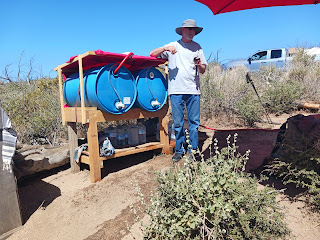
8 miles in, I got a pleasant surprise: a water cache. This one looks like it's been here a while with chairs, storage and large water barrels. As I drank my water and rested, I was joined by 5 other hikers. As we were resting a man drive up the dirt road just 50 feet north of us in a pickup with a 100 gallon water tank in the back. He told us he had been maintaining the water cache for 17 years. He proceeded with to refill all the water barrels and jugs and even left us oranges and other goodies.
 |
| Fresh fruit is always welcome on the trail |
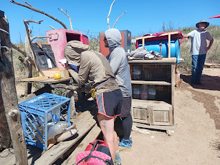 |
| Checking out the snacks |
The people who caught up with me had left Hikertown last night and made it to the canyon at 3 AM, waking me up. They slept till 6 and started hiking, joining me at the water cache. We resumed hiking at 10 with four of the fast hikers in the lead. As usual I was one of the last people to get to the road. Three of us hitched a ride to where we were staying, Hippy Hiker Haven.
Hippy Hiker Haven ( or as I like to call it 3H ) is one of the 3 best places I have stayed at so far. Granted, I'm sleeping on a cot in a yard with an outdoor shower and a portable commode but it beats Hikertown into miniscule, microscopic dust particles.
Sarah and John are friendly and pamper the hikers ( spoil us actually ).
 |
| A small sample of the goodies at Hippy Hiker Haven |
We could eat three meals a day and not pay a penny. We decided to eat at The Burger Spot and I tried an Ostrich Burger.
I must admit, I was a little underwhelmed. It didn't look or taste any different from a regular burger. No it didn't taste like chicken either.
Day 76: Slackpack to the Highway
Today was going to be a "typical" Zero ( do laundry, get resupply, recharge the electronics, check the FarOut comments for the upcoming stretch of trail and rest when two things happened:
1. I looked at the upcoming weather forecast. Tomorrow is going to be hot ( almost 90 ) but the following 3 days are going to be perfect ( about 70 ). So I will spend an extra day in Tehachapi ( I know. It will be such a hardship with the way Sarah and John spoil us )
2. Nathan aka "Status" decided to slackpack the last eight miles of this area. Allow me to explain.
 |
| Status on the move |
Yesterday we hiked the trail as far as Willow Springs road and hitched in from there. The trail also crosses Highway 58 and Kern Valley Transit has a bus stop there.
 |
| One of the locals ( not a Rattlesnake) |
 |
| Still hiking through the windfarm |
So Status and I slackpacked the PCT from Willow Springs Road to Highway 58 in 2 hours 45 minutes and then waited 1.5 hours for the bus to bring us back to Tehachapi. The reason there is a huge wind farm ( almost 20 miles wide ) is because the mountain ranges funnel the winds into this area and it is close to Los Angeles.
Day 77: Zero in Tehachapi
Today was the zero I should have had yesterday. In the morning I roamed down by the tracks (once a train buff, always a train buff ) and took photos of some of the buildings and murals.
In the afternoon. I hot my blog caught up and realized several people hadn't been getting it. Oops!!
Day 78: Second Zero in Tehachapi
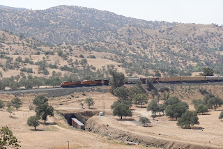
I took a second Zero in the hopes that I could get a ride to the famous ( among railfans at least ) Tehachapi Loop. The Tehachapi Loop is one of two places in North America where you can actually watch a train cross over ( or under depending on the direction of travel ) itself. Unfortunately I wasn't able to get a ride, so I spent an hour or so going through the Tehachapi Railroad Museum.
The museum is housed in a reconstruction of the combined Passenger/ Freight station that originally stood on the site. The first station ( built in 1904 ) burned down in the 1920s and was rebuilt. The 1920s station burned down (except for one wall) in 2008.
Volunteers rebuilt the rest of the station to the original specifications based on blueprints they found in Sacramento.
When they were removing the fire debris they found bricks from the original 1904 station under the floor.
In the evening I watched 4 trains go past the station in less than one hour. I would guess that each train was between 1.5 and 2 miles long.
Day 79: Zero Day - Tehachapi Loop
Today is my lucky day. Last night a group of hikers arrived. They had just completed the Tehachapi Challenge, hiking 41 miles from Hikertown to Tehachapi in less than 24 hours. They did stop for a 3 hour nap, but finished in 21 hours. Needless to say, they slept most of the morning...
Update: June 17. Alyssa has just reached Kennedy Meadows. She is now 140 miles ahead of me.








Comments
Post a Comment